I have two NavigraphData folders, one located in the ASFS install directory located in my D: drive (D:\HiFi\etc...) and the other one located in %AppData%\HiFi\etc.... After installing the new beta today and saying NO to the option of uninstalling the Navigraph AIRAC data during the previous ASFS uninstallation process, I had to re-install the AIRAC because the UI was still saying 2210. Because of that I had to point to the NavigraphData folder located in C:\%AppData%\HiFi, and I had finally the current AIRAC 2404 installed as shown in the UI. Looks like ASFS reads the Navigraph Data located in the %AppData% folder and not the one located in (my case) D:\HiFi\etc... Is that correct?. How to avoid this duplication of data location?.

NOTAM B8883 Posted Officially
- Thread starter damian
- Start date
- Status
- Not open for further replies.
same for me had to repoint the new destination and have it both installed. Does not matter I think.I have two NavigraphData folders, one located in the ASFS install directory located in my D: drive (D:\HiFi\etc...) and the other one located in %AppData%\HiFi\etc.... After installing the new beta today and saying NO to the option of uninstalling the Navigraph AIRAC data during the previous ASFS uninstallation process, I had to re-install the AIRAC because the UI was still saying 2210. Because of that I had to point to the NavigraphData folder located in C:\%AppData%\HiFi, and I had finally the current AIRAC 2404 installed as shown in the UI. Looks like ASFS reads the Navigraph Data located in the %AppData% folder and not the one located in (my case) D:\HiFi\etc... Is that correct?. How to avoid this duplication of data location?.
In fact, it doesn't matter, but it's inneficient and takes out your much needed disk space. I think the proper location should be at C:\%AppData%\HiFi\etc... folder and the uninstaller/installer should be modified accordingly, but it's up to HiFi to tell.same for me had to repoint the new destination and have it both installed. Does not matter I think.
ARz
New member
Active Sky Weather Depiction at SVMC
@POS 271540Z 14104KT 9999 -RA SCT125 28/16 Q1011 RMK AS DEPICTED
SVMC 271540Z 14404KT 9999 -RA BKN013 28/24 Q1011 RMK ADVANCED INTERPOLATION
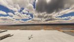
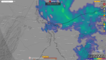
You can see there is no light rain as reported in the METAR.
That weather depiction is very wrong.
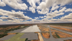
Satellite image from the moment at SVMC
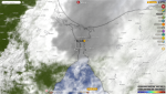
Radar layer
Edit: A friend told me there was a cloud ceiling with drizzle in some areas.
@POS 271540Z 14104KT 9999 -RA SCT125 28/16 Q1011 RMK AS DEPICTED
SVMC 271540Z 14404KT 9999 -RA BKN013 28/24 Q1011 RMK ADVANCED INTERPOLATION
You can see there is no light rain as reported in the METAR.
That weather depiction is very wrong.
Satellite image from the moment at SVMC
Radar layer
Edit: A friend told me there was a cloud ceiling with drizzle in some areas.
Last edited:
I thought you had one of the excellent SVMC addons available (one freeware, payware the other one)Active Sky Weather Depiction at SVMC
@POS 271540Z 14104KT 9999 -RA SCT125 28/16 Q1011 RMK AS DEPICTED
SVMC 271540Z 14404KT 9999 -RA BKN013 28/24 Q1011 RMK ADVANCED INTERPOLATION
View attachment 7922
View attachment 7923
You can see there is no light rain as reported in the METAR.
That weather depiction is very wrong.
Satellite image from the moment at SVMC
View attachment 7924
Radar layer
View attachment 7925

Last edited:
ARz
New member
That not mean i don't own it mate.I thought you had one of the excellents SVMC addons available (one freeware, payware the other one)
I've addon linker and the addon is deactivated for testing purposes
einherz
Active member
guys, looks like it's just don't works because i get full uninstall and reinstall again after restart pc. in the as window show connected, in flow weather show live weather, that's mean asobo. when close as, it's still same weather... when in older versions as works it's showed as carrier training weather. in 74 i could change frome live to any other and any other give me hifi weather, 8881 whatever i did only active sky weather till close active sky... for now whatever i do, active sky don't draw weather at all, i can set all presets in the flow menu and all works... active sky just do nothing. passive mod same - nothing... is it can be because i use su14 and all of you use su15?
?I just loaded in and got eh METAR just before this and this is what it shows:
@POS 271530Z 14404KT 9999 SCT092 28/20 Q1012 RMK AS DEPICTED
(Cloned by: SVMC, closest weather station when the aircraft was on the ground)
SCT092 extends to:17532 feet (Cloud type:CU, Turbulence:Light, Icing:None, Shear:Gradual, Cloud shape:Flat). Previous cloud: None, next cloud: None (Through extended weather data grid)
Surface winds calculated from the closest data grid point
Surface temperature calculated from the closest data grid point
This station has complete visibility information. No interpolation needed
Altimeter interpolation based on:
-TNCA 155nm NE (Q1012), SVBM 146nm SE (Q1015), SKVP 90nm SW (Q1012), SKRH 91nm NW (Q1010)
This station has complete Precipitation information. No interpolation needed
NOTE: Clouds, visibility and precipitation reported are the ones from the active cell weather
I advanced the time a little bit and got the METAR for the same time as you have it in your post, but it still doesn't show any rain and is the same as the one just prior:
@POS 271540Z 14404KT 9999 SCT092 28/20 Q1012 RMK AS DEPICTED
(Cloned by: SVMC, closest weather station when the aircraft was on the ground)
SCT092 extends to:17532 feet (Cloud type:CU, Turbulence:Light, Icing:None, Shear:Gradual, Cloud shape:Flat). Previous cloud: None, next cloud: None (Through extended weather data grid)
Surface winds calculated from the closest data grid point
Surface temperature calculated from the closest data grid point
This station has complete visibility information. No interpolation needed
Altimeter interpolation based on:
-TNCA 155nm NE (Q1012), SVBM 146nm SE (Q1015), SKVP 90nm SW (Q1012), SKRH 91nm NW (Q1010)
This station has complete Precipitation information. No interpolation needed
NOTE: Clouds, visibility and precipitation reported are the ones from the active cell weather
So... ASFS isn't depicting the wrong weather, as far as the METAR information that it has.
ARz
New member
????? You can watch at my comment above, i posted the conditions and METAR at that exact moment by AS. METAR shown -RA. Obviously after some minutes the rain moved to the NE and the conditions changed as you can see on the picture.I just loaded in and got eh METAR just before this and this is what it shows:
@POS 271530Z 14404KT 9999 SCT092 28/20 Q1012 RMK AS DEPICTED
(Cloned by: SVMC, closest weather station when the aircraft was on the ground)
SCT092 extends to:17532 feet (Cloud type:CU, Turbulence:Light, Icing:None, Shear:Gradual, Cloud shape:Flat). Previous cloud: None, next cloud: None (Through extended weather data grid)
Surface winds calculated from the closest data grid point
Surface temperature calculated from the closest data grid point
This station has complete visibility information. No interpolation needed
Altimeter interpolation based on:
-TNCA 155nm NE (Q1012), SVBM 146nm SE (Q1015), SKVP 90nm SW (Q1012), SKRH 91nm NW (Q1010)
This station has complete Precipitation information. No interpolation needed
NOTE: Clouds, visibility and precipitation reported are the ones from the active cell weather
I advanced the time a little bit and got the METAR for the same time as you have it in your post, but it still doesn't show any rain and is the same as the one just prior:
@POS 271540Z 14404KT 9999 SCT092 28/20 Q1012 RMK AS DEPICTED
(Cloned by: SVMC, closest weather station when the aircraft was on the ground)
SCT092 extends to:17532 feet (Cloud type:CU, Turbulence:Light, Icing:None, Shear:Gradual, Cloud shape:Flat). Previous cloud: None, next cloud: None (Through extended weather data grid)
Surface winds calculated from the closest data grid point
Surface temperature calculated from the closest data grid point
This station has complete visibility information. No interpolation needed
Altimeter interpolation based on:
-TNCA 155nm NE (Q1012), SVBM 146nm SE (Q1015), SKVP 90nm SW (Q1012), SKRH 91nm NW (Q1010)
This station has complete Precipitation information. No interpolation needed
NOTE: Clouds, visibility and precipitation reported are the ones from the active cell weather
So... ASFS isn't depicting the wrong weather, as far as the METAR information that it has.
View attachment 7927
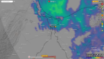
I got pictures about how is the weather there and definitely weather depiction from AS is very wrong. Also you can compare it with satellite radar and AS really doesn't match the real life conditions. Also I at least expect a 60% match vs real life, but it doesn't even close to that number. Your comment is really disappointing
Last edited:
ARz
New member
Also you i'm attaching a screenshot and you cant see there is a huge different from weather depiction you got vs my weather depiction.I just loaded in and got eh METAR just before this and this is what it shows:
@POS 271530Z 14404KT 9999 SCT092 28/20 Q1012 RMK AS DEPICTED
(Cloned by: SVMC, closest weather station when the aircraft was on the ground)
SCT092 extends to:17532 feet (Cloud type:CU, Turbulence:Light, Icing:None, Shear:Gradual, Cloud shape:Flat). Previous cloud: None, next cloud: None (Through extended weather data grid)
Surface winds calculated from the closest data grid point
Surface temperature calculated from the closest data grid point
This station has complete visibility information. No interpolation needed
Altimeter interpolation based on:
-TNCA 155nm NE (Q1012), SVBM 146nm SE (Q1015), SKVP 90nm SW (Q1012), SKRH 91nm NW (Q1010)
This station has complete Precipitation information. No interpolation needed
NOTE: Clouds, visibility and precipitation reported are the ones from the active cell weather
I advanced the time a little bit and got the METAR for the same time as you have it in your post, but it still doesn't show any rain and is the same as the one just prior:
@POS 271540Z 14404KT 9999 SCT092 28/20 Q1012 RMK AS DEPICTED
(Cloned by: SVMC, closest weather station when the aircraft was on the ground)
SCT092 extends to:17532 feet (Cloud type:CU, Turbulence:Light, Icing:None, Shear:Gradual, Cloud shape:Flat). Previous cloud: None, next cloud: None (Through extended weather data grid)
Surface winds calculated from the closest data grid point
Surface temperature calculated from the closest data grid point
This station has complete visibility information. No interpolation needed
Altimeter interpolation based on:
-TNCA 155nm NE (Q1012), SVBM 146nm SE (Q1015), SKVP 90nm SW (Q1012), SKRH 91nm NW (Q1010)
This station has complete Precipitation information. No interpolation needed
NOTE: Clouds, visibility and precipitation reported are the ones from the active cell weather
So... ASFS isn't depicting the wrong weather, as far as the METAR information that it has.
View attachment 7927

Definitely something isnt working well....
My comment is disappointing?!?!? Why???????? You can watch at my comment above, i posted the conditions and METAR at that exact moment by AS. METAR shown -RA. Obviously after 30-45 minutes the rain moved to the NE and the conditions changed as you can see on the picture.
View attachment 7928
I got pictures about how is the weather there and definitely weather depiction from AS is very wrong. Also you can compare it with satellite radar and AS really doesn't match the real life conditions. Also I at least expect a 60% match vs real life, but it doesn't even close to that number. Your comment is really disappointing
I'm pointing out that when trying to replicate your conditions, I get the METARs from ASFS as I copied in. I also pasted in a screenshot that includes the conditions. No rain shown on the METAR.
If your METAR that you copied over is from ASFS (and it seems like it would be), there seems to be an error in the METAR data between live mode and historical mode, which only Damian can address.
ARz
New member
Again. Obviously after some minutes the rain moved to the NE and the conditions changed. So, isn't the best to post a reply after several minutes when you know weather can change quickly.No rain shown on the METAR.
Now at this moment i get a similar METAR you had when replied my comment.
Edit: And of course that reports with -RA was from AS.
Last edited:
The METARs I showed are from BEFORE the one you showed and then the one you showed. I'm still perplexed about your reaction.Again. Obviously after 30 minutes the rain moved to the NE and the conditions changed. So, isn't the best to post a reply after several minutes when you know weather can change quickly.
Now at this moment i get a similar METAR you had when replied my comment.
Edit: And of course that reports with -RA was from AS.
einherz
Active member
i uninstall rex, thought there can be some conflict. no luck... just asobo weather. everything loaded connector, asfs itself, window shows all good, but no asfs weather, no way to see it in simulator. i even try instal 8881 same, back to 8883 same... what is it?
my cfg file... but i try with default settings too... what can so heavily kill the stuff?
my cfg file... but i try with default settings too... what can so heavily kill the stuff?
Attachments
-
565 bytes Views: 4
ARz
New member
Maybe i misunderstood, anyway my apologies. Also im trying to get through historical weather that metar and it doesnt match what i got in that moment (1540Z). Very weirdThe METARs I showed are from BEFORE the one you showed and then the one you showed. I'm still perplexed about your reaction.
Last edited:
Indeed. That is what I meant by Damian needing to address the difference in Live and Historical METARs.Maybe i missunderstood, anyway my apologies. Also im trying to get through historical weather that metar and it doesnt match what i got in that moment (1540Z). Very weird
ARz
New member
Btw, im getting a 1520Z METAR report but i set 1540Z in historical mode, do you know why this isnt exactly?Indeed. That is what I meant by Damian needing to address the difference in Live and Historical METARs.
Yes. I've mentioned it to Damian in a different thread. You need to move the time to something outside of the 60 minutes of the full hour you're looking at. For example, go to 1200Z. Then change the minutes to the ones you want and then the hours. The problem is that you've already downloaded weather data for sometime in the 60 minutes of 1500Z-1559Z.Btw, im getting a 1520Z METAR report but i set 1540Z in historical mode, do you know why this isnt exactly?
- Status
- Not open for further replies.